Speeding down a sandy and impossibly steep mountain road,
I’m still a bit faint from our earlier climb up to 5000m. The lunar landscape is populated only by
lichen and the occasional vicuña that I can’t appreciate because I’m too
focused on not injuring myself – a fall here would be bad news. My fingers are sore from constantly pumping
the brakes but I need to keep slowing myself down – both to keep track of Oscar,
who is somewhere behind me just out of sight, and because I can’t feel my hands
in the damp cold. The constant
thumpthumpthumpthump of the road vibrations are rattling my body, and make it
difficult for me to keep my hands on the brakes. It’s very cold. How could this get worse? I round a steep switchback somewhere around
4500m and ride right into a cloud – I can’t see a thing.
We just finished a fantastic four day mountain biking trip
that took us from the freezing heights of two of Ecuador’s highest volcanoes,
past volcanic craters, through indigenous villages, and down into the semi-tropics
on the border of the Oriente.
We weren’t actually biking for four days, just riding the downhills
– we had a van, piloted by our friendly and experienced driver/guide, Alberto,
and a great dog, Champy.
The tour agency
we used, the
Biking Dutchman, came highly recommended by an expat family we met
in Cuenca.
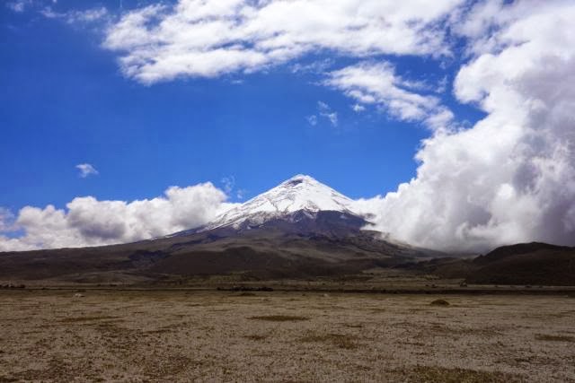
On the first day, we left Quito early for the two hour drive
to
Cotopaxi, perhaps the most famous of Ecuador’s volcanoes due to its perfect
conical form.
Yo and I had been here on
our visit 18 years ago and we were struck by the contrast.
What was then a turnoff in the narrow,
rutted, Panamerican Highway now had an entrance, visitors’ center and roads
similar to what you might find in any smaller US National Park.
We drove to a flat area of paramo, or high Andean grassland,
just below the base of the cone for a brief warm-up on our bikes, where even very
slight uphill stretches left us gasping due to the altitude. From there, we drove straight up to the
highest parking area, mounted up, and rode straight down the gravelly steep
road. Even though I bike a lot at home,
I found it very challenging and difficult to control my speed in the turns. I wondered, not for the last time, exactly
what I had signed us up for. But we always
had the truck right behind us, with the option to get in and ride for a
stretch, which Yo and Ruby took advantage of on some of the steeper parts. After the initial steep descent, we all descended
down the paved road to the park entrance.
 |
| Getting started |
 |
| Cotopaxi |
 |
| Wild horses |
 |
| At the uppermost parking lot on Cotopaxi |
 |
| View from Cotopaxi |
 |
| R speeding down the mountain |
 |
| And more downhill |
Our first day ended with another couple of hours in the car
as we drove to Quilotoa, an indigenous village high up in the clouds, situated
on the rim of a volcano’s crater lake.
We walked up to the crater rim to check it out, but the area was so
thickly covered in clouds, that we could barely see down to the lake. The Hostal Alpaka Quilotoa was exactly what I
imagined an Andean bunkhouse to be. The
owner, Patrona, an indigena matriarch wearing the traditional fedora, and her
family, presided over the comfortable but plain lodge, which featured a blazing
wood stove and hearty mountain fare.
Dinner was chicken/quinoa/potato soup, lamb (or goat?) stew with more
potatoes, rice, plantains and vegetables.
We shared the communal table with travellers from big mountain countries
– Argentina, Italy, Switzerland, Germany, and France, as well as Ecuador. Dinner was followed by cards (we’re playing a
lot of Hearts here, building up to teaching the kids Bridge) and some more time
by the fire, with the entire lodge asleep by 9:30.
The next day, we awoke early and after a big breakfast, walked
partially around the crater lake to one of the peaks on the edge. The weather had changed completely overnight
and we had a great sunny view down into the crater. From our vantage point, we could look across
the crater to the tallest peak (a sizable mountain in its own right), down to
impossibly blue water. Nothing lives in
the mineral-rich water. Tourists can
rent kayaks and swim if they can stand the cold. I’m sorry we didn’t have more time there – it
would have been nice to spend a day hiking around the rim and then down to the
lake, a full day trek. Many of the
fellow travellers we met were on a 5 day walk from village to village, which
would be wonderful to do on a return trip to Quilotoa.
 |
| lunch on the road |
 |
| Village scene |
 |
| Our lodge in Quilotoa |
 |
| Interior |
 |
| Exterior |
 |
| The crater lake through the clouds |
 |
| And in the clear, the following morning |
 |
| Snow-capped Ilinizas in the distance beyond the crater rim |
By 10 am, we were back on our bikes for a 15 km ride down a quiet
paved road to the small Quichua town of Zumbahua. We rode alongside a formidable gorge through
beautiful, farmed countryside filled, incongruously, with cactus. It was a great ride for the kids, especially
Ruby, who wasn’t a fan of the rough dirt roads.
We stopped long enough in Zumbahua to load up the bikes and
watch Champy dominate the local stray dogs.
Zumbahua hosts a huge weekly indigenous market, which unfortunately, we
missed by a day.
The Quichua men dress
“normally,” but the Quichua women, remarkably, wear felt “pork pie” hats, white
blouses and woolen ponchos, dark colored knee-length wool skirts, either white
knee socks or black lace pantyhouse, and black leather pumps with heels.
It’s a unique Austrian/Andean fashion
sensibility.
 |
| Oscar stopping to let traffic pass |
 |
| Studly British bikers riding from Alaska to Cape Horn - 3 1/2 years on the road! |
Next, we drove up for an hour or so to a remote ridge, had a
fantastic lunch, then got back on bikes for an amazing descent through high
grazing land, followed by hilly farmland whose small plot divisions looked like
someone had spread a green patchwork quilt over the mountains.
 |
| Lunch spot |
 |
| Patchwork mountainsides |

We then ended the day with a drive around and partially up
Chimborazo, Ecuador’s highest peak. Our hostal was set in a lonely stretch of paramo across from an old train station. Chimborazo was right there, but the clouds didn’t allow us to see much. The kids spent the last hour or so before dinner playing with Champy and the local dogs, and trying to touch the llamas, who seemed a bit stand-offish. Another hearty, communal mountain dinner and some chess games with O&R, and we again went to bed early. I had some trouble sleeping, which we had been told to expect due to the altitude.
The following morning, we awoke to cloudless, super-HD views
of Chimborazo, so vivid it almost seemed like a set.
 |
| View of Chimborazo from our hostal in the morning |
After breakfast, we drove over an hour to the
Chimborazo park, then up a steep winding road to the parking lot at 4800m.
As we ascended, the ground cover went from grass,
to cactus, then little grass, to lichen, to nothing at all.
From the parking lot, we walked up a bit,
then Oscar and I continued to the level of the highest mountaineering shelter –
5000m (about 16,500 ft.).
For us
sea-level natives, it was very hard walking, and we were impressed by locals
who booked by us, as well as by the half dozen or so climbers who passed us, coming
down from their all-night ascent to the summit.
 |
| O&I with the Whymper Refuge in the background. Above 5000m! |
By this time, we were very cold, and finally got on bikes for our first downhill of the day. The ride was cold, bumpy and steep, but a lot of fun, and as close to extreme sports as I care to get. When we entered the cloud, Yo and Ruby got on in the van, but O and I were too far ahead, so we just kept forging on, sometimes no visibility at all. We made it all the way down to the parking lot at the park entrance without even realizing it due to the zero visibility. But once we figured out where we were, we were more than happy to wait for Alberto and the van.
 |
| Descending Chimborazo |
After another drive and a lunch during which Alberto
introduced O&R to peanut butter and Nutella sandwiches, we had a beautiful
and not-too-steep descent down a paved road through a narrow green, river
valley, that reminded me at first of Switzerland, and later, California, as the
temperature rose and the farms changed from cows to fruit orchards (pears and
tomate de arbol).
We rode almost all the
way to Ambato, the largest city in the central part of the Sierra, then back in
the van for the two hour drive down even more to sub-tropical Baños.
 |
| Descending toward Ambato |
Arriving in Baños felt like coming back to civilization
after a few days in the high mountains.
Famed for its natural hot springs, Baños is very much a tourist town, filled
with pizza places, ice cream, backpackers and wifi. Our accommodation was at a more conventional
small tourist hotel. For dinner, we had
Pad Thai at a place run by some guy from the Bay Area.
Our final day, we got a much later start, more than welcome
after the past three days. We rode
straight out of the hotel, down the “Avenue of the Orchids”, the road to Puyo
and the Oriente. It was an easy ride,
down a spectacular river valley, with walls rising up thousands of feet on
either side, and descending way down below us to a raging river. Because it was Sunday, and because this is a
major road, there was a lot more traffic than we had seen before, so in that
sense, the riding was less comfortable.
The highlight of the day was our final destination, El Pailón del Diablo
(The Devil’s Cauldron), a huge waterfall that tumbles into a never-ending,
swirling pit before entering the river.
It was worth the half-hour hike to get down to the base, and then up to
the cave that puts you literally behind the waterfall as it spews from the
mountain. After lunch at the restaurant
by the waterfall, we drove back to Baños, said our farewells to Alberto and
Champy, and settled in for some much needed rest.
 |
| Cable car across the Pastaza River. No way! |
 |
| A rest stop on the Avenue of the Orchids |
 |
| Aberto, Champy, R&O at the end of the trip |
The four-day trip was a true highlight of our time in
Ecuador, and I’m looking forward to more family biking trips. I’m particularly proud of Ruby for holding up
on those steep mountain roads!

2 comments:
Amazing stuff!!! Way to go on the altitude! Miss you guys - JPZ
so cool. no better way to appreciate the topography of a place than to work your way up, and be rewarded on the way down.
Post a Comment